
This afternoon, after checking my gopher traps, I could see the river was higher than the 890 CFS peak over a week ago. Then 5 hours later, when checking the traps a second time, I could see the river was even higher. The water is not just brown but the color of mud. Lots of erosion going on.
The local news said 10 rock slides went across Going-to-the-sun road in Glacier Nat'l Park. Avalanche Creek in the Park went over its banks closing the hiking trail. (Francis, Tina, Larry... remember that trail?) The west reservoir road near Hungry Horse Dam is completely washed out in one area as shown on the 6 pm news.
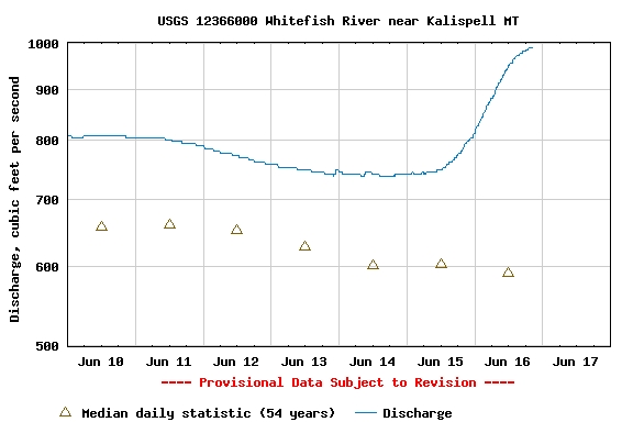
Here is the chart from the USGS for tonight. I took the chart with the 10:30 pm reading as the flow was 991 CFS. The 12:30 am flow was at 1000 CFS exactly, and the chart was resized to go to a maximum of of 2000 CFS. The increase is not as dramatic on that chart.
Note that on Thursday morning (15th) the flow was less than 750 CFS. (I seem to remember it at 741). A pretty steep increase of 250 CFS in a day and a half!


(Click on the images to see their larger version.)

No comments:
Post a Comment